Il n'y a pas une annotation en français. Présenté est une annotation en Anglais.
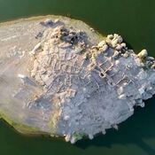
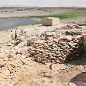
Aşıklı Höyük that located at the western edge of the Taurus Mountain Range, in the nearnest of an obsidian sources and in fertile land was occupied from Aceramic Neolithic period, around 9000 BC1.
See:
- Mihriban Özbaşaran, Re-starting at Aşıklı, In: Anatolia Antiqua, Tome XIX, 2011. pp. 27-37.
- http://www.asiklihoyuk.org/
- Gregory Mumford, Anth.245 Ppt. lecture-2: Neolithic Anatolia, Part-1: Background, Gobelki Tepe, Nevali Cori, and case study on Chatal Huyuk (Part-1: setting; social organization; subsistence; technology) (Anth.245: Mediterranean Area, by G. Mumford; Sept. 2020)
Références
- ↑https://en.wikipedia.org/wiki/A%C5%9F%C4%B1kl%C4%B1_H%C3%B6y%C3%BCk