
Il n'y a pas une annotation en français. Présenté est une annotation en Néerlandais.
Watling Street (West). Zie M.C. Bishop: The Secret History of the Roman Roads of Britain


Watling Street (West). Zie M.C. Bishop: The Secret History of the Roman Roads of Britain
Watling Street (West). Zie M.C. Bishop: The Secret History of the Roman Roads of Britain
IA Settlement.
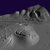
Iron Age Settlement
Iron Age Settlement