
Roman Road between London and Silchester

Localisation:
- Royaume-Uni, Crowthorne
- geo:51.372379,-0.774027
- Précision ± 0-5 m.
Classification:
- Voie romaine
- Visible
Identificateurs:
- vici:place=19568
Annotations
See Ordnance Survey Maps:
http://maps.nls.uk/view/97793440 ; http://maps.nls.uk/view/97793536 ; http://maps.nls.uk/view/97793470 ; http://maps.nls.uk/view/97793386 ; http://maps.nls.uk/view/97793419 ; http://maps.nls.uk/view/97793098
À proximité
Wickham Bushes Settlement (1 km)
Wickham Bushes Settlement
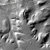
Caesar's Camp, Bracknell Forest (1 km)
Iron Age hill fort
Milestone on London to Silchester Road (Road 4a) (7 km)
Milestone