

Roman Road between Badbury Rings and Old Sarum

Localisation:
- Royaume-Uni, Salisbury
- geo:51.06625,-1.83541
- Précision ± 0-5 m.
Classification:
- Voie romaine
- Visible
Identificateurs:
- vici:place=19557
- wikidata:entity=Q4674275
Annotations
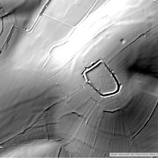
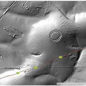
This segment of the extended Portway between Old Sarum and Badbury Rings is called the Ackling Dyke and has an exceptionally high agger. It is road segment 4c in Margary,
À proximité
Little Woodbury (3 km)
Little Woodbury an Iron Age archaeological site near the city of Salisbury.
Sorbiodoni (3 km)
OmnesViae import OVPlace482
Roman Road between Winchester and Old Sarum (6 km)
Roman Road between Winchester and Old Sarum