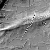
The Fosse Way was one of the major Roman Roads in Britain, running from the coast near Seaton to Lincoln (Lindum)
This segment from Ilchester to Bath is shown in Margary as Road 5B.


The Fosse Way was one of the major Roman Roads in Britain, running from the coast near Seaton to Lincoln (Lindum)
This segment from Ilchester to Bath is shown in Margary as Road 5B.
Roman Road from Aquis Sulis to Durnonovaria
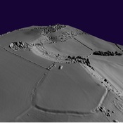
Ponter's Ball linear earthwork
Iron Age Settlement
Temple complex