
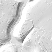
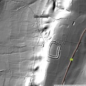
Roman Road from Lindum to Aquis Sulis

Localisation:
- Royaume-Uni, Grittleton
- geo:51.521618,-2.223814
- Précision ± 0-5 m.
Classification:
- Voie romaine
- Visible
Identificateurs:
- vici:place=19154
Annotations
The Fosse Way was one of the major Roman Roads in Britain, running from the coast near Seaton to Lincoln (Lindum)
This segment from Bath to Cirencester is shown in Margary as Road 5C
À proximité
Castle Combe (2 km)
Medieval settlement.
Nettleton Temple (4 km)
Rustic Shrine
Villa at Truckle Hill (4 km)
Villa at Truckle Hill (MONUMENT NO. 208315)