
Vicus Abritus1
Er zijn nog geen afbeeldingen met betrekking tot deze plaats toegevoegd.
Afbeelding toevoegen.
Afbeelding toevoegen.
Omgeving:

Locatie:
- Bulgarije, Razgrad
- geo:43.523163,26.555515
- Locatie ± 5-25 m.
Classificatie:
- Vicus of canabae
- Zichtbaar
Identifiers:
- vici:place=14625
Annotaties

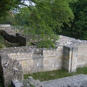
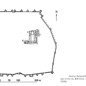
The earliest data of human presence in Hisarlaka Area to the east of modern-day Razgrad date back to the Paleolithic Age ( 18 000 – 15 000 BC). Thracian settlement existed in the IV – III centuries BC. It becames Roman settlement in the first century BC. During Roman period Abritus was strongly fortified town in Moesia Inferior.
See:
- http://abritus.org/en/abritusmoreinfo/abritusprezwekowete.html
- Efthymios Rizos, Centres of the late roman military supply network in the Balkans: a survey of horrea, In: Römisch-Germanisches Zentralmuseum: Jahrbuch des Römisch-Germanischen Zentralmuseums Mainz, Heidelberg 2013, pp. 659-696
In de buurt
Hoard of gold coins
The largest late empire hoard of gold coins in Bulgaria was found just inside the eastern wall consisting of 835 gold coins weighing 4 kg (8.8 lb) and dating from the 5th century, probably hidden during the invasion of the Goths 487.
Abritus (Razgrad, Bulgarian)
Abritus
Abritus, Christian Complex
IVth century church - episcopal complex?