Il n'y a pas une annotation en français. Présenté est une annotation en Anglais.
Roman Brittain refers to this site as a posting station and probable Mansio, as does Pastscape. Both call it the Ipiing site.


Roman Brittain refers to this site as a posting station and probable Mansio, as does Pastscape. Both call it the Ipiing site.
Roman Brittain refers to this site as a posting station and probable Mansio, as does Pastscape. Both call it the Ipiing site.
Villa at Liss ()
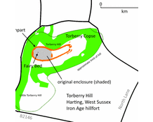
Tarberry Hill - Torbery Hill is an Iron Age hill fort in the county of West Sussex,
Villa at Batten Hanger (MONUMENT NO. 246266)