
Roman Brittain refers to this site as a posting station and probable Mansio, as does Pastscape. Both call it the Ipiing site.

Surroundings:

Location:
- United Kingdom of Great Britain and Northern Ireland, Milland
- geo:51.02763,-0.798044
- Location ± 0-5 m.
Class:
- Rural settlement
- visible
Identifiers:
- vici:place=14559
Annotations
Nearby
Villa at Liss (8 km)
Villa at Liss ()
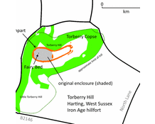
Torberry Hill (8 km)
Tarberry Hill - Torbery Hill is an Iron Age hill fort in the county of West Sussex,
Villa at Batten Hanger (11 km)
Villa at Batten Hanger (MONUMENT NO. 246266)