Es gibt noch keine deutschsprachige Anmerkungen. Präsentiert wirden Anmerkungen auf English.
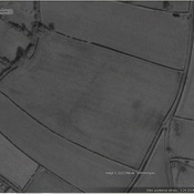
The area around Burgh-by-Sands is dotted with Roman military encampments, which were all placed at this strategic location to guard two nearby Solway fords, frequently used by raiding parties from the northern tribes, especially the Selgovae to the north and possibly also the Novantae in the north-west. Aside from the Hadrianic fortifications there are two earlier auxiliary forts and a number of marching camps. The Burgh village church is built from stones taken from the Wall, and marks the location of the southern defences of the fort. Evidence of a small civilian settlement or vicus has also been found outside the fort's south-eastern defences.
Evidence From Classical Sources
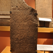
The name of the fort appears first in the Notitia Dignitatum of the early-fifth century, wherein is listed the station Aballaba, between the entries for Petrianis (Stanwix, Cumbria) and Congavata (Drumburgh, Cumbria). The Burgh-by-Sands fort also appears in the seventh-century Ravenna Cosmography as Avalana), between the entries for Uxelludamo (another name for Stanwix) and Maia (Bowness on Solway, Cumbria).
The name is recorded in 1292 as Burg en le Sandes, and before that simply as Burch (c.1180). The origin of these names obviously stems from the Old English burh, meaning fortification or stronghold, its more modern name also referring to the location of the old Roman fort among the sandy dunes of the Solway estuary.
See also
The area around Burgh-by-Sands is dotted with Roman military encampments, which were all placed at this strategic location to guard two nearby Solway fords, frequently used by raiding parties from the northern tribes, especially the Selgovae to the north and possibly also the Novantae in the north-west. Aside from the Hadrianic fortifications there are two earlier auxiliary forts and a number of marching camps. The Burgh village church is built from stones taken from the Wall, and marks the location of the southern defences of the fort. Evidence of a small civilian settlement or vicus has also been found outside the fort's south-eastern defences.
Evidence From Classical Sources
The name of the fort appears first in the Notitia Dignitatum of the early-fifth century, wherein is listed the station Aballaba, between the entries for Petrianis (Stanwix, Cumbria) and Congavata (Drumburgh, Cumbria). The Burgh-by-Sands fort also appears in the seventh-century Ravenna Cosmography as Avalana), between the entries for Uxelludamo (another name for Stanwix) and Maia (Bowness on Solway, Cumbria).
The name is recorded in 1292 as Burg en le Sandes, and before that simply as Burch (c.1180). The origin of these names obviously stems from the Old English burh, meaning fortification or stronghold, its more modern name also referring to the location of the old Roman fort among the sandy dunes of the Solway estuary.
See also