Er zijn nog geen Nederlandstalige annotaties. Hier volgen annotaties in het Engels.
Listed in Ptolemy's Geography as Alauna, one of three towns he attributes to the Otalini or Otadini tribe, and occurring between the entries for CORSTOPITVM (Corbridge) and BREMENIVM(High Rochester), both sites in modern Northumberland. The name Alauna also appears in the Ravenna Cosmology between the unidentified entries Coccimeda and Oleiclavis, very likely also in Northumberland.
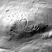
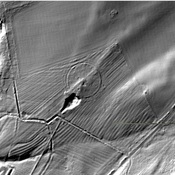
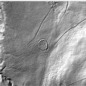
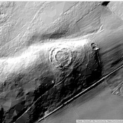
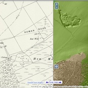
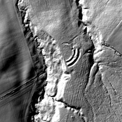
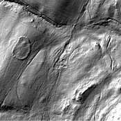
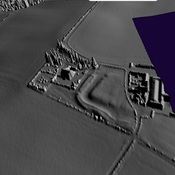
The Learchild fort is situated on the south bank of the River Aln, which is itself identified with the Alaunus of Ptolemy, and the Alauna of the Ravenna Cosmology.
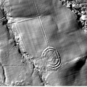
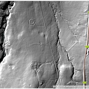
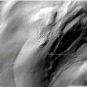
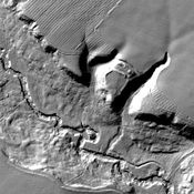
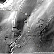
Discovered from the air by Professor St. Joseph in 1945, it measures approximately 800 x 600 ft. across the defences, an area of about 11 acres (c.244 x 183m; 4.4 ha), which is quite substantial for a permanent fort and easily big enough to house three, possibly even four, auxiliary infantry cohorts, or a couple of wings of auxiliary cavalry, or likely enough a mixture of the two types; either way, the garrison here would have numbered easily over a thousand men. Further A.P.'s taken in the early-1950's revealed at least two periods of construction; the fort evidently either expanding or contracting its defences, no doubt in order to accommodate garrison units of differing strengths1.
See also
Bronverwijzingen
- ↑RBO: Alauna Votadinum
Listed in Ptolemy's Geography as Alauna, one of three towns he attributes to the Otalini or Otadini tribe, and occurring between the entries for CORSTOPITVM (Corbridge) and BREMENIVM(High Rochester), both sites in modern Northumberland. The name Alauna also appears in the Ravenna Cosmology between the unidentified entries Coccimeda and Oleiclavis, very likely also in Northumberland.
The Learchild fort is situated on the south bank of the River Aln, which is itself identified with the Alaunus of Ptolemy, and the Alauna of the Ravenna Cosmology.
Discovered from the air by Professor St. Joseph in 1945, it measures approximately 800 x 600 ft. across the defences, an area of about 11 acres (c.244 x 183m; 4.4 ha), which is quite substantial for a permanent fort and easily big enough to house three, possibly even four, auxiliary infantry cohorts, or a couple of wings of auxiliary cavalry, or likely enough a mixture of the two types; either way, the garrison here would have numbered easily over a thousand men. Further A.P.'s taken in the early-1950's revealed at least two periods of construction; the fort evidently either expanding or contracting its defences, no doubt in order to accommodate garrison units of differing strengths1.
See also
Bronverwijzingen
- ↑RBO: Alauna Votadinum