
Vici.org
No images available yet. Please add images related to this place.

Surroundings:

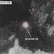
IRAQ_Lower Euphrates_1968_AS (EUAS-70)EUAS-65_Anonymous settlement_Map site_Wright (1966), in ADAMS (1981), p. 337 (fig 26)

Location:

  • Iraq, Al Bunūd
  • geo:31.109266,45.857632
  • Location ± 0-5 m.

Class:

  • Archaeological observation
  • visible

Identifiers:

  • vici:place=104244

Annotations


Nearby

Ishan al-Kharita (EUAS-69) (4 km)

Neo-Babylonian and later periods settlement. Surveyed by T. Wright (1966).

Anonymous settlement (EUAS-68) (4 km)

Late Larsa and Neo-Babylonian settlement (0,2 ha). Surveyed by T. Wright (1966).

Unidentified site (5 km)

Probable archaeological site, badly damaged. Located with satellite imagery. Better visible on Corona imagery (1968).


This object was added by Julien De Chocqueuse on 2026-09-22. Last update by Julien De Chocqueuse on 2026-09-22. Persistent URI: http://vici.org/vici/104244 . Download as RDF/XML, KML.
Annotation available using the Creative Commons Attribution-ShareAlike 3.0 Unported license. Metadata available using the Creative Commons Public Domain Dedication, unless it is explicitly stated otherwise.

Vici.org partners:

Livius.org: articles on ancient history   Rijksmuseum van Oudheden