Vici.org
Il n'y a pas d'images. Télécharger une image.

Les environs:

localisation of Mur (dit) de Hannibalplan of excavationsinscription in alphabet roman javelinroman sicklenails for roman military sandalsexcavations of Mur (dit) de Hannibal in 2014roman nail of a sandalexcavations of Mur (dit) de Hannibal in 2014plate of a roman scale armourexcavations of Mur (dit) de Hannibal in 2016excavations of Mur (dit) de Hannibal in 2015wall of Mur (dit) de Hannibal

Localisation:

  • Suisse, Bourg-Saint-Pierre
  • geo:45.949226,7.208195
  • Précision ± 0-5 m.

Classification:

  • Borne routière
  • Visible

Identificateurs:

  • vici:place=10220

Annotations


Typ/Type: Infrastruktur - Meilenstein / Infrastructure - Milestone


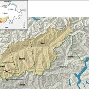
Provinz/Province: Alpes Gaiae et Poeninae


Adresse/Address: 1946 Bourg-St-Pierre, Schweiz


errichtet/built: 310

Untergang/Decline: ?


Siehe/See Further:


À proximité

Mur (dit) de Hannibal (4 km)

Late republican fort dated to second half of the 1st century BC

Wachthaus (Bourg-St-Pierre) (8 km)

Wachthaus (Bourg-St-Pierre)