
No annotations have been added. Please add information about this place.

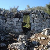
Location:
- Greece, Ágios Ilías
- geo:38.482658,21.288601
- Location ± 0-5 m.
Period or year:
- -3xx?~ / unknown
Class:
- City
- visible
Identifiers:
- vici:place=101762
- pleiades:place=530907
Annotations
Nearby
Paianion (Mastro) (4 km)
Fortified town razed by Philip V in 219 bce.
Magoula - Aitolikon (Pylene?) (8 km)
Hellenistic to Roman settlement on spur N of old Magoula, NE of Aitoliko
Koulia of kyra-Vassiliki (8 km)
Late Byzantine watchtower.