


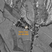
No annotations have been added. Please add information about this place.

Location:
- Uzbekistan, Indaly
- geo:38.038254,67.820526
- Location ± 0-5 m.
Class:
- Archaeological observation
- invisible
Identifiers:
- vici:place=97539
Annotations
Nearby
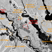
Anonymous site (Uz-SD-578)
Medieval (?) site. Small mound (0,15 ha), indicated on 1951 topographical map, and already destroyed by 1970. Surveyed by MAFOuz.
Unidentified site (1 km)
Probable archaeological site. Oval mound, visible on Corona imagery (1970), since destroyed by urbanisation.
Kul' Tepe (Uz-SD-253) (2 km)
Also known as Shait Tepe. Kushan, early Medieval and pre-Mongol settlement (0,2 ha). Area of small mounds, mostly destroyed by modern cultivation. Studied by Rtveladze & Khakimov, and MAFOuz.