
STRIDE, S. (2004), La Géographie archéologique de la province du Surkhan Darya (Bactriane du Nord, Ouzbekistan du Sud). Unpublished dissertation at the Université panthéon-Sorbonne (Paris), 5 vols. ( https://sirisacademic.academia.edu/SebastianStride?swp=tc-au-44230952 )
 - UZB-SD_1970_Kichik Tepe 490")
Surroundings:


Location:
- Uzbekistan, Denov
- geo:38.242115,67.914886
- Location ± 0-5 m.
Period or year:
- 9xx / 10xx
Class:
- Rural settlement
- invisible
Identifiers:
- vici:place=97302
Annotations
Nearby
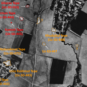
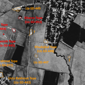
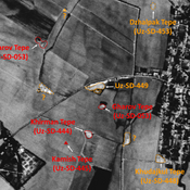
Namazga Tepe (Uz-SD-071)
Also known as G'o'z Tepe or Katta Tepe. Late Kushan settlement. Rectangular site (1,3 ha), formally surrounded by small tepes, since destroyed, that could mark a larger lower town. Studied by Arshavskaja and MAFOuz.
Jingil Tepe (Uz-SD-393)
Indistinct mound, visible on Corona imagery (1970), that could mark the limit of nearby Namazga Tepe lower town. Destroyed by modern cultivation. Pre-modern (16-17e s.) ceramics finds in the fields.
Kattabang Kurgan (Uz-SD-388) (1 km)
Kushan and pre-Mongol Islamic settlement (> 0,5 ha). Low circular mound, visible on Corona imagery (1970), destroyed by modern cultivation. Studied by MAFOuz.