
STRIDE, S. (2004), La Géographie archéologique de la province du Surkhan Darya (Bactriane du Nord, Ouzbekistan du Sud). Unpublished dissertation at the Université panthéon-Sorbonne (Paris), 5 vols. ( https://sirisacademic.academia.edu/SebastianStride?swp=tc-au-44230952 )
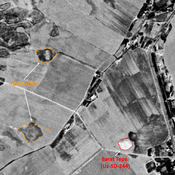
 Corona imagery (1970) - UZB-SD_1970_AS 027 (Yangi Haytobod)")
Surroundings:

Location:
- Uzbekistan, Yangi Haytobod
- geo:37.569973,67.450371
- Location ± 0-5 m.
Period or year:
- 8xx / 13xx
Class:
- Rural settlement
- invisible
Identifiers:
- vici:place=97147
Annotations
Nearby
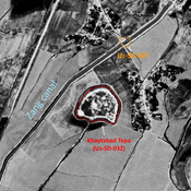
Khaytabad Tepa (Uz-SD-032)
Also known as Khajtabad Tepe. Achaemenid (Yaz III / Kuchuk III-IV) and Medieval walled settlement (6 ha). Stratigraphical trench by Sabirov and Annaev (1977, 1986), studied by MAFOUB (1993-1997).
Unidentified site
Probable archaeological site. Rectangular mound, visible on Corona imagery (1970), since leveled.
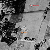
Anonymous site (2 km)
Former very small tepa, visible on Corona imagery (1970), destroyed by ploughing in the second half of the 22th c. No dating information.