
STRIDE, S. (2004), La Géographie archéologique de la province du Surkhan Darya (Bactriane du Nord, Ouzbekistan du Sud). Unpublished dissertation at the Université panthéon-Sorbonne (Paris), 5 vols. ( https://sirisacademic.academia.edu/SebastianStride?swp=tc-au-44230952 )

Location:
- Uzbekistan, Minor
- geo:37.47662,67.396263
- Location ± 0-5 m.
Period or year:
- 1108~ / 18xx
Class:
- Temple or sanctuary
- visible
Identifiers:
- vici:place=96916
Annotations
Nearby
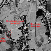
Charmangan - Sarmanjan
Area, in modern Minor village, identified by Bartol'd as the medieval town of Charmangan / Sarmanjan. Several mounds and architectural remains in the vicinity.
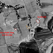
Minor tepe (Uz-SD-341) - ancient Charmangan ?
Former mound, entirely destroyed by urbanisation by 2000. No dating information. Reported by Annaev. Area identified by Bartol'd as the medieval town of Charmangan / Sarmanjan.
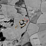
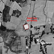
Kul' Tepe (Uz-SD-031)
Pre-Mongol settlement. Small tepe ((0,075 ha) and larger ceramic scatter, forming a micro-relief visible on Corona imagery (1970), covered by a modern cemetery and badly damaged in the 2000's. Studied by Arshavskaja and Rtveladze. Area identified by Bart