
STRIDE, S. (2004), La Géographie archéologique de la province du Surkhan Darya (Bactriane du Nord, Ouzbekistan du Sud). Unpublished dissertation at the Université panthéon-Sorbonne (Paris), 5 vols. ( https://sirisacademic.academia.edu/SebastianStride?swp=tc-au-44230952 )
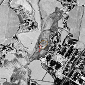
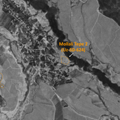
 - UZB-SD_1970_Chorgul' Tepe I 216")
Surroundings:


Location:
- Uzbekistan, Sho‘rchi
- geo:38.001579,67.766182
- Location ± 0-5 m.
Period or year:
- 4xx~ / 8xx~
Class:
- Rural settlement
- visible
Identifiers:
- vici:place=96775
Annotations
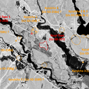
Nearby
Kul' Tepe Dzhoil'ma (Uz-SD-250) (1 km)
Kushan settlement (1,3 ha). Already partially destroyed in 1970. Studied by Pugachenkova and Rtveladze.
Sasy Tepe (Uz-SD-214) (1 km)
Early Medieval settlement (0,5 ha). Studied by Arshavskaja & Rtveladze.
Unidentified site (1 km)
Probable archaeological site. Mound visible on Corona imagery (1970), since destroyed by urbanisation.