
STRIDE, S. (2004), La Géographie archéologique de la province du Surkhan Darya (Bactriane du Nord, Ouzbekistan du Sud). Unpublished dissertation at the Université panthéon-Sorbonne (Paris), 5 vols. ( https://sirisacademic.academia.edu/SebastianStride?swp=tc-au-44230952 )
 - UZB-SD_1970_Dzhar Tepe 190")
Surroundings:


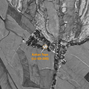


Location:
- Uzbekistan, Indaly
- geo:38.059982,67.820396
- Location ± 0-5 m.
Period or year:
- 10? / 18xx?
Class:
- Rural settlement
- visible
Identifiers:
- vici:place=96721
Annotations
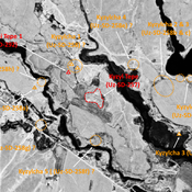
Nearby
Unidentified site (1 km)
Probable archaeological site. Oval mound, visible on Corona imagery (1970), since destroyed by urbanisation.
Unidentified site (2 km)
Probable archaeological site. Square mound, visible on Corona imagery (1970), since destroyed by urbanisation.
Chorgul' Tepe II (Uz-SD-217 & 251) (2 km)
Also known as Boj Bobo Kabriston Tepe and Dengak Tepe. Kushan, early Medieval and pre-Mongol settlement (1 ha). Dual site, with a square tepe in the SE, and a lower one in the NW (used as a cemetery). In similar state as in 1970. Studied by Rtveladze and