
STRIDE, S. (2004), La Géographie archéologique de la province du Surkhan Darya (Bactriane du Nord, Ouzbekistan du Sud). Unpublished dissertation at the Université panthéon-Sorbonne (Paris), 5 vols. ( https://sirisacademic.academia.edu/SebastianStride?swp=tc-au-44230952 )
 - UZB-SD_1970_Bul'bul Tepe 185")
Surroundings:


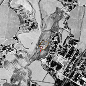

Location:
- Uzbekistan, Garmatepa
- geo:37.984447,67.819412
- Location ± 0-5 m.
Period or year:
- 4xx / 7xx
Class:
- Vicus or canabae
- visible
Identifiers:
- vici:place=96717
Annotations
Nearby
Unidentified site
Probable archaeological site. Very small mound, located with satellite imagery.
Ilonli Tepe (Uz-SD-249)
Kushan settlement (1 ha). Uncertain identification with site B57 of Rtveladze.
Unidentified site (1 km)
Probable archaeological site. Small square mound, visible on Corona imagery (1970), since leveled and destroyed by urbanisation.