
STRIDE, S. (2004), La Géographie archéologique de la province du Surkhan Darya (Bactriane du Nord, Ouzbekistan du Sud). Unpublished dissertation at the Université panthéon-Sorbonne (Paris), 5 vols. ( https://sirisacademic.academia.edu/SebastianStride?swp=tc-au-44230952 )
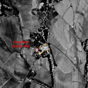
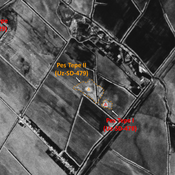
 - UZB-SD_1970_Khumdan Tepe 108")
Surroundings:


Location:
- Uzbekistan, Uzun
- geo:38.371735,68.027466
- Location ± 0-5 m.
Period or year:
- 4xx / 12xx
Class:
- Vicus or canabae
- invisible
Identifiers:
- vici:place=96678
Annotations
Nearby
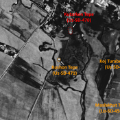
Kafir Kala (Uz-SD-103) (1 km)
Also known as Navanal Tepe. Early, High and Late Medieval, and pre-Modern town-size settlement (20 ha). Large square site, with a rectangular citadel in its center, and smaller tepe in its outskirts. Studied by Arshavskaja & Rtveladze.
Kul' Tepe (Uz-SD-099) (1 km)
Early Medieval site (0,01 ha). Undescribed. Published in Arshavskaja & Rtveladze. Destroyed by modern construction, but small mound visible on Corona imagery (1970).
Kabriston Tepe (Uz-SD-096) (1 km)
Early Medieval settlement (0,36 ha). Studied by Arshavskaja & Rtveladze.