
STANCO Ladsilav (2020), Sherabad Oasis - Tracing Historical Landscape in Southern Uzbekistan, Karolinum, Nakladatelstvi Univerzity Karlovy,Czech Republic

Location:
- Uzbekistan, Talishkan
- geo:37.586723,66.92247
- Location ± 0-5 m.
Period or year:
- 4xx / 800~
Class:
- Rural settlement
- invisible
Identifiers:
- vici:place=96223
Annotations
Nearby
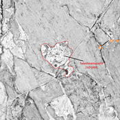
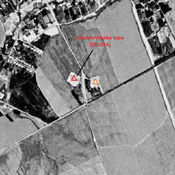
Talashkantepa III (SO-099) (Uz-SD-166)
Kushan & Kushano-Sasanian, and High Medieval settlement (9,5 ha). Already badly damaged by 1970, its southern part destroyed by modern agriculture in recent years, but visible on Corona imagery. Studied by Arshavskaja & Rtveladze, and surveyed by Stanco.
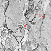
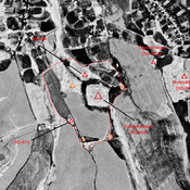
Talashkantepa II (SO-032) (Uz-SD-228) (1 km)
Kushan & Kushano-Sasanian, and Early Medieval settlement (4,8 ha). Pentagonal mound. Surveyed by Stanco (2005, 2010).
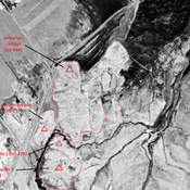
Talashkantepa II (SO-072) (Uz-SD-228) (1 km)
Post-mongol north western mound of Talashkantepa II. Surveyed by Stanco (2005, 2010).