


STRIDE, S. (2004), La Géographie archéologique de la province du Surkhan Darya (Bactriane du Nord, Ouzbekistan du Sud). Unpublished dissertation at the Université panthéon-Sorbonne (Paris), 5 vols. ( https://sirisacademic.academia.edu/SebastianStride?swp=tc-au-44230952 )

Location:
- Uzbekistan, Tolli
- geo:38.12854,67.868935
- Location ± 0-5 m.
Period or year:
- 6xx / 7xx
Class:
- Rural settlement
- visible
Identifiers:
- vici:place=95270
Annotations
Nearby
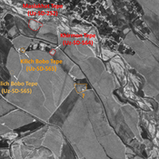
Anonymous settlement (Uz-SD-606)
Pre-modern settlement, but possibly older. Mostly rectangular site (0,3 ha), indicated on 1951 topographical map, whose eastern part is almost destroyed by modern cultivation since the 1960's. Surveyed and dated by MAFOuz.
Anonymous site (Uz-SD-310) (1 km)
Kushan and early Medieval site (0,15 ha). Destroyed before 1978. Studied by Iskhakov & Malikov, and MAFOuz.
Karaul Tepe (Uz-SD-196) (1 km)
Early Medieval settlement, interpreted as a castle by Ishakov and Malikov (1978) (0,25 ha). Studied by Arshavskaja & Rtveladze, and MAFOuz.