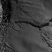
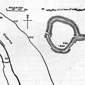
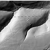
Vici.org

Surroundings:

Plan of the Bury Castle, 1911Bury CastleGrabbist HillBlack Ball CampPorlockMap of earthworks at Bat's Castle, Somerset, England. 1911Berry Castle Wood

Location:

  • United Kingdom of Great Britain and Northern Ireland, West Myne
  • geo:51.223846,-3.525217
  • Location ± 0-5 m.

Period or year:

  • -1xxx? / unknown

Class:

  • Castle
  • visible

Identifiers:

  • vici:place=91921

Annotations


Nearby

Selworthy Beacon (1 km)

Round cairn cemetery.

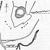
Bury Castle, Selworthy (2 km)

Bury Castle is an Iron Age hill fort near Selworthy, Somerset, England

Grabbist Hill (6 km)

Hillfort on Grabbist Hill


This object was added by Ludwinski on 2023-11-20. Last update by Ludwinski on 2023-11-20. Persistent URI: http://vici.org/vici/91921 . Download as RDF/XML, KML.
Annotation available using the Creative Commons Attribution-ShareAlike 3.0 Unported license. Metadata available using the Creative Commons Public Domain Dedication, unless it is explicitly stated otherwise.

Vici.org partners:

Livius.org: articles on ancient history   Rijksmuseum van Oudheden