Vici.org

Surroundings:

cASTELO OUREMPonte da AtouguiaPonte dos NamoradosPonte dos NamoradosMelroeira bridge (abandoned)Melroeira old bridgeOlaia bridgePonte da ValadaCaminho da ponte da Valada-Seiça1972 finding in a tavern's backyardTomareisruinsruinsruinsruinsCastelo do CarrapatosoCastelo do CarrapatosoCastelo do CarrapatosoCastelo do CarrapatosoCastelo do CarrapatosoCastelo do Carrapatoso

Location:

  • Portugal, Mulher Morta
  • geo:39.641048,-8.595214
  • Location ± 0-5 m.

Period or year:

  • 11xx? /

Class:

  • Road
  • visible

Identifiers:

  • vici:place=88245

Annotations

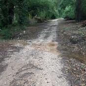
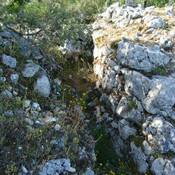
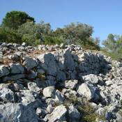
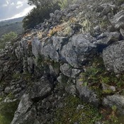
The paved roads located next to Fonte dos Cavalos and Mulher Morta appear to be medieval, but may have originated in Roman times. 
These two paved roads, about 2 meters wide, are built with limestone and some pebbles and have wedge stones, delimiting the verges and the central axis of the road.


In 2016 in the crossroad of "Mulher Morta" it was excaveted another area of paved road, and after the conclusion of the works, protected with another layer of new cobblestone road (suitable for modern vehicles)


Nearby

Castelo de Ourém

pré-história, sucessivamente ocupado por Romanos, Visigodos e Muçulmanos. Estes últimos aí terão erguido uma fortificação.

Ponte da Atouguia (1 km)

It is a perfect back arch bridge built with limestone slabs.

Ponte dos Namorados (1 km)

Ponte dos Namorados as seen in 195x


This object was added by Hugo on 2023-08-15. Last update by Hugo on 2023-08-15. Persistent URI: http://vici.org/vici/88245 . Download as RDF/XML, KML.
Annotation available using the Creative Commons Attribution-ShareAlike 3.0 Unported license. Metadata available using the Creative Commons Public Domain Dedication, unless it is explicitly stated otherwise.
Line tracing by Hugo.

Vici.org partners:

Livius.org: articles on ancient history   Rijksmuseum van Oudheden