Vici.org
No images available yet. Please add images related to this place.

Surroundings:

Freyaskring_QGISWodenberg_QGISVraHulle wiel_QGISDen HeksennestDen HeksennestDen Heksennest_drone_001Den Heksennest_drone_002DrieMaters_001DrieMaters_002DrieMaters_003Malegijswal_001Malegijswal_002Vlietberg_QGISRomeinse greppels MelkspideHunnenketel_001

Location:

  • Belgium, Rooien
  • geo:50.984234,4.113558
  • Location ± 5-25 m.

Period or year:

  • 1xx / unknown

Class:

  • Road
  • visible

Identifiers:

  • vici:place=83578

Annotations

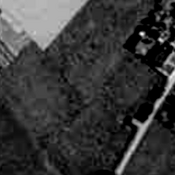
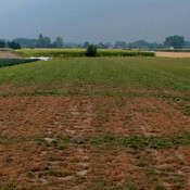
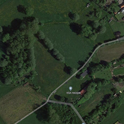
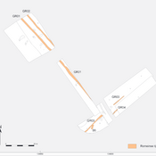
Possible roman road leading to the vicus of Kalkoven, Asse.


Nearby

Freyaskring

Freyaskring, restanten (cropmarks) op oude luchtfotografiebeelden.

Wodenberg

Wodenberg, restanten (cropmarks) op oude luchtfotografiebeelden.

VraHulle wiel

VraHulle wiel, mogelijke dubbele circulaire structuur op oude luchtfoto.


This object was added by BartV on 2023-01-28. Last update by Lieven on 2023-02-04. Persistent URI: http://vici.org/vici/83578 . Download as RDF/XML, KML.
Annotation available using the Creative Commons Attribution-ShareAlike 3.0 Unported license. Metadata available using the Creative Commons Public Domain Dedication, unless it is explicitly stated otherwise.

Vici.org partners:

Livius.org: articles on ancient history   Rijksmuseum van Oudheden