


STRIDE, S. (2004), La Géographie archéologique de la province du Surkhan Darya (Bactriane du Nord, Ouzbekistan du Sud). Unpublished dissertation at the Université panthéon-Sorbonne (Paris), 5 vols. ( https://sirisacademic.academia.edu/SebastianStride?swp=tc-au-44230952 )

Location:
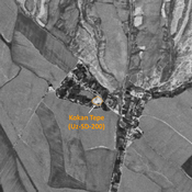
- Uzbekistan, Olatemir
- geo:38.08007,67.808205
- Location ± 0-5 m.
Period or year:
- 10~ / 10xx
Class:
- Rural settlement
- visible
Identifiers:
- vici:place=78498
Annotations
Nearby
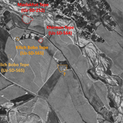
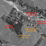
Dzhar Tepe (Uz-SD-190) (2 km)
Kushan (?), early Medieval (?) and modern settlement (1,1 ha). Polygonal site, badly damaged. Differences of datation between Arshavskaja & Rtveladze, and MAFOuz.
Anonymous site (Uz-SD-282) (3 km)
Kushan site. Used as a modern cemetery. Studied by Iskharov and Malikov.
Kirkkir Tepe (Uz-SD-187) (3 km)
Also known as Gaibata Tepe. Pre-modern small circular site (0,04 ha). Destroyed by modern housing. Uncertain identification with site n°187 by Arshavskaja & Rtveladze.