
STRIDE, S. (2004), La Géographie archéologique de la province du Surkhan Darya (Bactriane du Nord, Ouzbekistan du Sud). Unpublished dissertation at the Université panthéon-Sorbonne (Paris), 5 vols. ( https://sirisacademic.academia.edu/SebastianStride?swp=tc-au-44230952 )
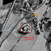
 - UZB-SD_1970_Yalpak Tepa 033")
Surroundings:
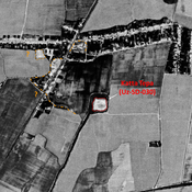

Location:
- Uzbekistan, Abuz
- geo:37.492077,67.417366
- Location ± 0-5 m.
Period or year:
- 10~ / 17xx
Class:
- Vicus or canabae
- visible
Identifiers:
- vici:place=73465
Annotations
Nearby
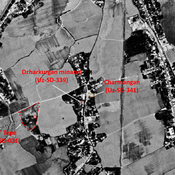
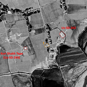
Ismail Tepe (Uz-SD-241) (2 km)
Graeco-Bactrian, Kushan and early Medieval settlement (1,5 ha). Rectangular site with a citadel in its north-western corner. Studied by Rtveladze.
Minor tepe (Uz-SD-341) - ancient Charmangan ? (2 km)
Former mound, entirely destroyed by urbanisation by 2000. No dating information. Reported by Annaev. Area identified by Bartol'd as the medieval town of Charmangan / Sarmanjan.
Dzharkurgan minaret (Uz-SD-339) (2 km)
Medieval Islamic circular minaret, the only remain of a Seljuk Friday Mosque, destroyed in the XIXe c. Studied by Arshavskaja & Rtveladze. Area identified by Bartol'd as the medieval town of Charmangan / Sarmanjan.