There is no English annotation yet. Presented is an annotation in German.
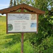
Schwaben, Unterallgäu, Bad Wörishofen, Schlingen
Bodendenkmal Denkmalnummer D-7-8029-0028 u.a. Siedlung der römischen Kaiserzeit


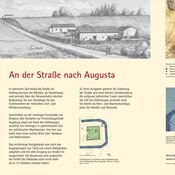
Schwaben, Unterallgäu, Bad Wörishofen, Schlingen
Bodendenkmal Denkmalnummer D-7-8029-0028 u.a. Siedlung der römischen Kaiserzeit
Schwaben, Unterallgäu, Bad Wörishofen, Schlingen
Bodendenkmal Denkmalnummer D-7-8029-0028 u.a. Siedlung der römischen Kaiserzeit
Burgus Schlingen
römische Siedlung
Römerstraße Navoae - Rostrum Nemaviae