Vici.org
No images available yet. Please add images related to this place.

Surroundings:

Bruck, Neuburg a.d.DonauEitensheimGaimersheim

Location:

  • Germany, Irgertsheim
  • geo:48.755672,11.301924
  • Location ± 5-25 m.

Class:

  • Road
  • invisible

Identifiers:

  • vici:place=47880

Annotations

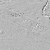
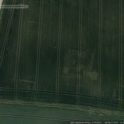
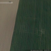
There is no English annotation yet. Presented is an annotation in German.

Oberbayern, Ingolstadt (Stadt), Irgertsheim

Bodendenkmal Denkmalnummer D-1-7233-0091 Straße der römischen Kaiserzeit.


In der Nähe gibt es eine Infotafel zum Auenweg Kulturlandschaft Gerolfinger Eichenwald, die auf eine römische Töpferei & Ziegelei östlich des Hohenlohbergs verweist.

Oberbayern, Ingolstadt (Stadt), Irgertsheim

Bodendenkmal Denkmalnummer D-1-7233-0091 Straße der römischen Kaiserzeit.


In der Nähe gibt es eine Infotafel zum Auenweg Kulturlandschaft Gerolfinger Eichenwald, die auf eine römische Töpferei & Ziegelei östlich des Hohenlohbergs verweist.


Nearby

Roman Rd (3 km)

Roman Rd

Roman Rd (4 km)

Roman Rd

Bruck, Neuburg a.d.Donau (4 km)

Fortlet/Watchtower


This object was added by Kai G. on 2018-01-13. Last update by Kai G. on 2018-01-13. Persistent URI: http://vici.org/vici/47880 . Download as RDF/XML, GeoJSON, KML.
Annotation available using the Creative Commons Attribution-ShareAlike 3.0 Unported license. Metadata available using the Creative Commons Public Domain Dedication, unless it is explicitly stated otherwise.
Line tracing by Ludwinski.

Vici.org partners:

Livius.org: articles on ancient history   Rijksmuseum van Oudheden