Vici.org

Surroundings:

Hasankeyf BridgeHasankeyf FortUlu Cami (Mosque)

Location:

  • Türkiye, Serpir
  • geo:37.715504,41.410461
  • Location ± 0-5 m.

Class:

  • City
  • visible

Identifiers:

  • vici:place=43058

Annotations

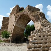
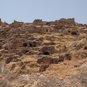
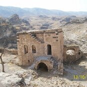
Ilānṣurā an important walled city on a large river according to texts of the Mari Tablets (1800–1750 BC), has been tentatively identified with Hasankeyf. The site is a circular mound about 150 min diameter and 8 m high above the surroundings. The main traces of ocuupations are from the 10th millennium cal. BC.

See:

  1. http://www.turkishculture.org/archaeology/hasankeyf-1082.htm
  2. Michael C. Astour, "The North Mesopotamian Kingdom of Ilānșurā", in Young, Gordon Douglas, Mari in Retrospect, Winona Lake, Indiana: American Oriental Society/Eisenbrauns 1992, pp. 1–33
  3. Yutaka Miyake, Osamu Maeda, Kenichi Tanno, Hitomi Hongo and Can Y. Gündem, New Excavations at Hasankeyf Höyük: A 10th millennium cal. BC site on the Upper Tigris, Southeast Anatolia, Neo-Lithics, 1/12, pp. 3-7

Nearby

Hasankeyf Bridge

Hasankeyf Bridge

Riskepha - Fort at Kepha

(Ris)Kepha(s) - Fort; AD 300 - AD 640; Pleiades #874664; Hasankeyf Citadel.

Ulu Cami (Mosque)

Ulu Cami (Mosque)


This object was added by Elżbieta on 2017-07-12. Last update by Elżbieta on 2017-09-25. Persistent URI: http://vici.org/vici/43058 . Download as RDF/XML, GeoJSON, KML.
Annotation available using the Creative Commons Attribution-ShareAlike 3.0 Unported license. Metadata available using the Creative Commons Public Domain Dedication, unless it is explicitly stated otherwise.

Vici.org partners:

Livius.org: articles on ancient history   Rijksmuseum van Oudheden