Vici.org
Il n'y a pas d'images. Télécharger une image.

Les environs:

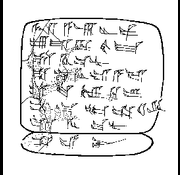
Tell Hadidi Text No. 8

Localisation:

  • Syrie, Zarījat Shams ad Dīn
  • geo:36.219395,38.129166
  • Précision ± 0-5 m.

Period or year:

  • -2000~ / -1600~

Classification:

  • Sanctuaire
  • Visible

Identificateurs:

Annotations

Il n'y a pas une annotation en français. Présenté est une annotation en Anglais.

The late Bronze Age - Altsyrian period (about 2000 - 1600 BC) temple located at the northwestern edge of the ruins of the Euphrates in the inner city.

See:

  1. https://en.wikipedia.org/wiki/Mumbaqat
  2. Douglas Neal Petrovich, Tayinat's Building XVI: The Religious Dimensions and Significance of a Tripartite Temple at Neo-Assyrian Kunulua (University of Toronto: NMC Department), University of Toronto 2016 p. 267
  3. v\Alfred Werner Maurer, Tall Munbaqa / Ekalte (Mumbaqat) - http://mumbaqat.npage.de/0-tall-munbaqa-ekalte-mumbaqat.html

À proximité

Mumgabat - Ekalte [Tall Munbāqa], Temple II

Mumgaqat - Ekalte [Tall Munbāqa], Temple II

Mumbagat - Ekalte [Tall Munbāqa], Temple III

Mumgaqat - Ekalte [Tall Munbāqa], Temple III

Mumgabat - Ekalte

Tall Munbāqa