Vici.org
No images available yet. Please add images related to this place.

Surroundings:

Doseme BogaziBademagacı (Kizilkaya). Plan with the Christian BasilicaBademagaci Hoyuk. Plan of the EBA II settlements

Location:

  • Türkiye, Dağ
  • geo:37.198429,30.572479
  • Location ± 25-100 m.

Class:

  • Grave or burial field
  • visible

Identifiers:

  • vici:place=37871

Annotations


Nearby

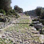
Doseme Bogazi (Via Sebaste)

The ancient road at Doseme Bogazi ("paved passage" in Turkish) dates back to the Hellenistic period, which is when the road posts and several watch towers were built. The second phase of the road is dated to the Roman period.

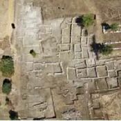
Market building (3 km)

Market building, constructed until Selcuk and Ottoman Times.

Kovanlık (4 km)

Milestone


This object was added by Ludwinski on 2017-03-06. Last update by Ludwinski on 2017-03-06. Persistent URI: http://vici.org/vici/37871 . Download as RDF/XML, GeoJSON, KML.
Annotation available using the Creative Commons Attribution-ShareAlike 3.0 Unported license. Metadata available using the Creative Commons Public Domain Dedication, unless it is explicitly stated otherwise.

Vici.org partners:

Livius.org: articles on ancient history   Rijksmuseum van Oudheden