


https://blogdelvidriovisigodo.wordpress.com/yacimientos/
La ciudad de Recópolis, tal y como nos describen las fuentes escritas, se situó en la Celtiberia, que actualmente comprendería gran parte de las provincias de Guadalajara y Cuenca. Limítrofe con esta por el occidente se situaría la Carpetania, donde se localiza la capital del Estado visigodo, Toledo, y con su límite nororiental en el valle del río Henares.
La fundación de una ciudad de nueva planta, como es el caso de Recópolis en el 578 por el rey Leovigildo en honor a su hijo Recaredo, conllevó muchas transformaciones en el paisaje de la zona. Así, se desforestaron muchas zonas para contribuir al abastecimiento de la construcción de nuevos edificios y para la explotación de nuevos cultivos que surtirán de alimentos a los nuevos pobladores de la ciudad.
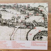
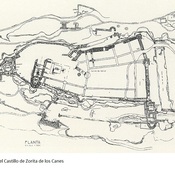
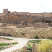
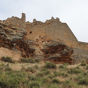
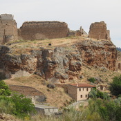
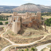
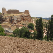
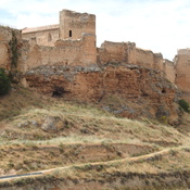
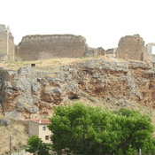
La interrelación entre las poblaciones de la región se modificó drásticamente, recurriendo a la nueva ciudad como centro polarizador de todo el territorio. Se realizaron nuevas vías de comunicación y de traslado de mercancías para un comercio centralizado y, que indudablemente, deberían comunicar por una de sus vías con la capital, Toledo. En este sentido hay que destacar la situación geográfica en la que se ubicó la ciudad de Recópolis. Situada en un cerro amesetado de unas 30 H de extensión, está dominando uno de los meandros del río Tajo, comunicador directo con la capital. La topografía de la ciudad y su urbanismo se definieron, de hecho, por las características físicas de este cerro, las cuales obligaron a realizar parte de las construcciones de forma escalonada en las diferentes terrazas, así como en los destacables aterrazamientos artificiales efectuados sobre el terreno.
El sistema de explotación económica estaba definido por una utilización mixta agrícola y ganadera. El ganado, de mayor porcentaje ovicápridos, seguidos de bovinos y suinos no evita que se destine un esfuerzo complementario a la caza del ciervo, jabalí y conejo, abundantes en el paisaje de bosque espeso que debía de existir en la época. Con respecto a la explotación agrícola estaría reservada en las ricas tierras de aluvión, en la vega del río, con cultivos como trigo, cebada y olivares, estos últimos ya en las pequeñas mesetas circundantes a la ciudad.
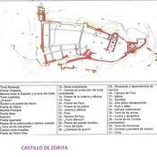
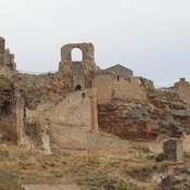
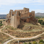
El urbanismo de la ciudad está dominado por el Conjunto Palatino situado en la parte más alta del cerro y formado por una serie de edificios dispuestos alrededor de una gran plaza. Este conjunto de edificios, además de alojar a los altos dignatarios, estaban dedicados a la administración y gobierno de la ciudad y su territorio. Las principales construcciones tenían dos plantas. Su construcción se fecha a finales del siglo VI y primeras décadas del siglo VII y, en su estudio arqueológico se ha evidenciado una serie de reformas y reorientaciones.
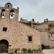
En la zona oriental de la plaza se encuentra la iglesia palatina, el templo más importante de la ciudad. De planta de cruz latina su división en diferentes espacios respondía a las necesidades funcionales de la liturgia. La cabecera, formada por el ábside -que albergaba el altar- y el crucero, eran los espacios reservados para el clero. La nave central era el lugar destinado a los fieles, las personas bautizadas. dos naves colaterales flanqueaban a la central y se comunicaban directamente con el transepto, de ellas situada al norte tenía la función de sacristía.
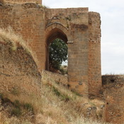
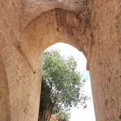
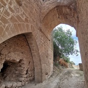
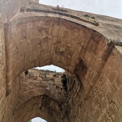
El acceso a este conjunto palatino se efectuaba a través de una gran Puerta Monumental, una de las construcciones más significativas de la ciudad. Actualemente tan solo se conserva su basamento, pero sabemos que estaba formada por dos arcos y bóveda de dovelas inscritos en una construcción rectangular. Esta puerta se edificó en un momento inmediatamente posterior a la construcción original del conjunto palacial y muestra como el proceso de monumentalización de la ciudad no terminó con la fundación, sino que prosiguió con posterioridad a esta.
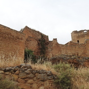
De la Puerta Monumental nacía en dirección sur una gran vía principal en la que se situaban a ambos lados dos grandes edificios destinados a actividades comerciales y artesanas, en tiendas con sus correspondientes talleres o almacenes. Estos edificios estaban compartimentados por una serie de módulos de planta rectangular, con un modelo fijo, con dos espacios reducidos que daban directamente a la calle, separados por un pasillo de entrada, y que tenían la función de tiendas, y una gran estancia situada en la parte posterior utilizada como taller o almacén. En el edificio comercial situado al oeste, en el módulo V, se ha podido documentar la existencia del primer taller de vidrio delimitado de la Península y fechado su construcción y uso a finales del siglo VI d.C. Pero también se han hallado restos de otro tipo de actividades en otros módulos, como el taller de un orfebre, y en otro caso un punto de venta de materiales procedentes de todo el ámbito mediterráneo.
El hallazgo de diversas monedas por toda la Península en la que se especifica su fabricación o ceca de Recópolis, nos llevan a pensar en la existencia de una fábrica de moneda en esta ciudad, aunque por el momento, y analizando los restos arqueológicos, no se ha podido deducir su espacio físico dentro del área excavada.
Pero ¿qué es una ciudad sin espacios de vivienda en la que puedan vivir sus habitantes? Las viviendas que hasta el momento se han podido excavar serían tres, una al sureste de la gran vía principal y, otras dos, al oeste del edificio comercial oeste, una a continuación de la otra. La excavación de estas viviendas nos han ofrecido no sólo una amplísima información del tipo de construcción de las mismas, sus reformas a lo largo del tiempo, sino también una gran cultura material que nos destacan la forma de vida de los habitantes en el día a día.
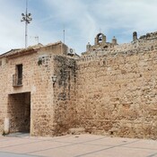
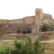
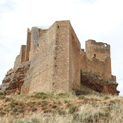
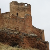
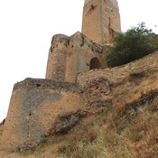
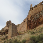
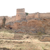
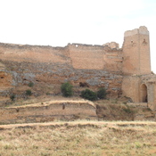
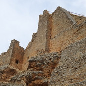
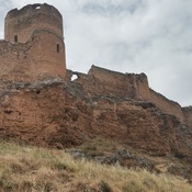
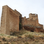
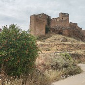
La ciudad de Recópolis, como se ha dicho anteriormente, ocupaba una extensión de 30 hectáreas (de las cuales tan sólo se han podido excavar un 8% aproximadamente) y estaba rodeada toda ella por una gran muralla jalonada por torres cuadrangulares y semicirculares y con una de las puntos de acceso hallado en la zona oeste de la ciudad. La muralla era un elemento fundamental sin el cual una ciudad no podía ser considerada como tal. De hecho, además de delimitar el espacio urbano, y más allá de una mera función defensiva, su carácter monumental estaba destinado a resaltar el poder y la magnificiencia de Recópolis como elemnto de propaganda ciudadana.
_________
The city of Reccopolis, as written sources describe us, was located in Celtiberia, which today would comprise a large part of the provinces of Guadalajara and Cuenca. Bordering on this to the west would be the Carpetania, where the capital of the Visigoth state, Toledo, is located, and with its northeast limit in the valley of the Henares river.
The foundation of a new city, as is the case of Reccopolis in 578 by King Leovigildo in honor of his son Recaredo, led to many transformations in the landscape of the area. Thus, many areas were deforested to contribute to supplying the construction of new buildings and for the exploitation of new crops that will supply food to the new inhabitants of the city.
The interrelation between the populations of the region was drastically modified, resorting to the new city as a polarizing center of the entire territory. New routes of communication and transfer of merchandise were created for a centralized trade and, undoubtedly, they should communicate through one of their routes with the capital, Toledo. In this sense, the geographical situation in which the city of Reccopolis was located must be highlighted. Located on a plateau-shaped hill some 30 hours long, it overlooks one of the meanderings of the Tagus River, a direct link to the capital. The topography of the city and its urban planning were defined, in fact, by the physical characteristics of this hill, which made it necessary to carry out part of the constructions in a staggered manner on the different terraces, as well as in the remarkable artificial terracing carried out on the ground. .
The economic exploitation system was defined by a mixed agricultural and livestock use. Livestock, with a higher percentage of ovicápridos, followed by cattle and pigs, does not prevent a complementary effort from being devoted to hunting deer, wild boar and rabbit, which were abundant in the thick forest landscape that must have existed at the time. With regard to agricultural exploitation, it would be reserved in the rich alluvial lands, in the fertile plain of the river, with crops such as wheat, barley and olive groves, the latter already on the small plateaus surrounding the city.
The urban planning of the city is dominated by the Palatine Complex located on the highest part of the hill and made up of a series of buildings arranged around a large square. This set of buildings, in addition to housing the high dignitaries, were dedicated to the administration and government of the city and its territory. The main buildings had two floors. Its construction dates back to the end of the 6th century and the first decades of the 7th century and, in its archaeological study, a series of reforms and reorientations have been evidenced.
In the eastern part of the square is the palatine church, the most important temple in the city. With a Latin cross plan, its division into different spaces responded to the functional needs of the liturgy. The head, formed by the apse -which housed the altar- and the transept, were the spaces reserved for the clergy. The central nave was the place for the faithful, the baptized people. two collateral naves flanked the central one and communicated directly with the transept, of which, located to the north, it served as a sacristy.
Access to this palace complex was through a large Monumental Gate, one of the most significant buildings in the city. Currently only its base is preserved, but we know that it was made up of two arches and a voussoir vault inscribed in a rectangular construction. This gate was built immediately after the original construction of the palatial complex and shows how the process of monumentalizing the city did not end with its foundation, but continued after it.
From the Monumental Gate a great main road was born in a southerly direction in which two large buildings for commercial and craft activities were located on both sides, in shops with their corresponding workshops or warehouses. These buildings were compartmentalized by a series of modules with a rectangular floor plan, with a fixed model, with two small spaces that opened directly onto the street, separated by an entrance corridor, and that had the function of shops, and a large room located in the back used as a workshop or warehouse. In the commercial building located to the west, in module V, it has been possible to document the existence of the first delimited glass workshop on the Peninsula and its construction and use have been dated to the end of the 6th century AD. But remains of other types of activities have also been found in other modules, such as a goldsmith's workshop, and in another case a point of sale for materials from all over the Mediterranean area.
The discovery of various coins throughout the Peninsula in which their manufacture or Recópolis mint is specified, lead us to think of the existence of a mint in this city, although for the moment, and analyzing the archaeological remains, it is not has been able to deduce its physical space within the excavated area.
But what is a city without housing spaces in which its inhabitants can live? The houses that have been excavated so far would be three, one to the southeast of the main road and two others, to the west of the west commercial building, one after the other. The excavation of these houses has offered us not only extensive information on the type of construction of the same, their reforms over time, but also a great material culture that highlights the way of life of the inhabitants on a day-to-day basis. .
The city of Reccopolis, as has been said previously, occupied an area of 30 hectares (of which only approximately 8% have been excavated) and was all surrounded by a great wall marked out by quadrangular and semicircular towers and with a of the access points found in the western part of the city. The wall was a fundamental element without which a city could not be considered as such. In fact, in addition to delimiting the urban space, and beyond a mere defensive function, its monumental character was intended to highlight the power and magnificence of Recópolis as an element of citizen propaganda.
__________
La ville de Recopolis, comme nous le décrivent des sources écrites, était située en Celtiberia, qui comprendrait aujourd'hui une grande partie des provinces de Guadalajara et de Cuenca. En bordure de celle-ci à l'ouest se trouverait la Carpetania, où se trouve la capitale de l'État wisigoth, Tolède, et avec sa limite nord-est dans la vallée de la rivière Henares.
La fondation d'une nouvelle ville, comme c'est le cas de Recopolis en 578 par le roi Leovigildo en l'honneur de son fils Recaredo, a entraîné de nombreuses transformations dans le paysage de la région. Ainsi, de nombreuses zones ont été déboisées pour contribuer à approvisionner la construction de nouveaux bâtiments et pour l'exploitation de nouvelles cultures qui fourniront de la nourriture aux nouveaux habitants de la ville.
L'interrelation entre les populations de la région a été radicalement modifiée, recourant à la nouvelle ville comme centre de polarisation de l'ensemble du territoire. De nouvelles voies de communication et de transfert de marchandises ont été créées pour un commerce centralisé et, sans aucun doute, elles devraient communiquer par l'une de leurs routes avec la capitale, Tolède. En ce sens, la situation géographique dans laquelle se trouvait la ville de Recopolis doit être soulignée. Situé sur une colline en forme de plateau d'environ 30 heures de long, il surplombe l'un des méandres du Tage, lien direct avec la capitale. La topographie de la ville et son urbanisme ont été définis, en effet, par les caractéristiques physiques de cette colline, ce qui a nécessité de réaliser une partie des constructions de manière échelonnée sur les différentes terrasses, ainsi que dans les remarquables aménagements artificiels terrassement réalisé sur le terrain. .
Le système d'exploitation économique était défini par une utilisation mixte agricole et d'élevage. L'élevage, avec un pourcentage plus élevé d'ovicápridos, suivi par les bovins et les porcs, n'empêche pas qu'un effort complémentaire soit consacré à la chasse au cerf, au sanglier et au lapin, qui abondaient dans l'épais paysage forestier qui devait exister à l'époque. En ce qui concerne l'exploitation agricole, elle serait réservée aux riches terres alluviales, dans la plaine fertile du fleuve, avec des cultures telles que le blé, l'orge et les oliveraies, ces dernières déjà sur les petits plateaux entourant la ville.
L'urbanisme de la ville est dominé par le Complexe palatin situé sur la partie la plus élevée de la colline et composé d'une série de bâtiments disposés autour d'une grande place. Cet ensemble de bâtiments, en plus d'abriter les hauts dignitaires, était dédié à l'administration et au gouvernement de la ville et de son territoire. Les bâtiments principaux avaient deux étages. Sa construction remonte à la fin du VIe siècle et aux premières décennies du VIIe siècle et, dans son étude archéologique, une série de réformes et de réorientations ont été mises en évidence.
Dans la partie orientale de la place se trouve l'église palatine, le temple le plus important de la ville. Avec un plan en croix latine, sa division en différents espaces répondait aux besoins fonctionnels de la liturgie. Le chevet, formé par l'abside -qui abritait l'autel- et le transept, étaient les espaces réservés au clergé. La nef centrale était le lieu des fidèles, des baptisés. deux nefs collatérales flanquaient la centrale et communiquaient directement avec le transept, dont, situé au nord, il servait de sacristie.
L'accès à ce complexe de palais se faisait par une grande porte monumentale, l'un des bâtiments les plus importants de la ville. Actuellement seule sa base est conservée, mais on sait qu'elle était composée de deux arcs et d'une voûte en voussoir inscrite dans une construction rectangulaire. Cette porte a été construite immédiatement après la construction originale du complexe palatial et montre comment le processus de monumentalisation de la ville ne s'est pas terminé avec sa fondation, mais s'est poursuivi après elle.
De la Porte Monumentale est née une grande route principale en direction du sud dans laquelle deux grands bâtiments pour les activités commerciales et artisanales étaient situés de part et d'autre, dans des magasins avec leurs ateliers ou entrepôts correspondants. Ces bâtiments étaient compartimentés par une série de modules de plan rectangulaire, à modèle fixe, avec deux petits espaces qui s'ouvraient directement sur la rue, séparés par un couloir d'entrée, et qui avaient la fonction de commerces, et une grande pièce située à l'arrière utilisé comme atelier ou entrepôt. Dans le bâtiment commercial situé à l'ouest, dans le module V, il a été possible de documenter l'existence du premier atelier de verre délimité de la péninsule et sa construction et son utilisation ont été datées de la fin du VIe siècle après JC. Mais des vestiges d'autres types d'activités ont également été retrouvés dans d'autres modules, comme un atelier d'orfèvrerie, et dans un autre cas un point de vente de matériaux provenant de tout le pourtour méditerranéen.
La découverte de diverses pièces de monnaie dans toute la péninsule dans laquelle leur fabrication ou l'atelier de Recopolis est spécifié, nous amène à penser à l'existence d'un atelier de monnaie dans cette ville, bien que pour le moment, et en analysant les vestiges archéologiques, il n'ait pas été possible de déduire son espace physique au sein de la zone fouillée.
Mais qu'est-ce qu'une ville sans espaces de logement dans lesquels ses habitants peuvent vivre ? Les maisons fouillées jusqu'à présent seraient au nombre de trois, une au sud-est de la route principale et deux autres, à l'ouest du bâtiment commercial ouest, l'une après l'autre. La fouille de ces maisons nous a offert non seulement de nombreuses informations sur le type de construction de celles-ci, leurs réformes au fil du temps, mais aussi une grande culture matérielle qui met en valeur le mode de vie des habitants au quotidien. .
La ville de Recopolis, comme cela a été dit précédemment, occupait une superficie de 30 hectares (dont seulement environ 8% ont été fouillés) et était le tout entouré d'une grande muraille délimitée par des tours quadrangulaires et semi-circulaires et avec un des points d'accès situés dans la partie ouest de la ville. La muraille était un élément fondamental sans lequel une ville ne pouvait être considérée comme telle. En effet, en plus de délimiter l'espace urbain, et au-delà d'une simple fonction défensive, son caractère monumental visait à mettre en valeur la puissance et la magnificence de Recópolis en tant qu'élément de propagande citoyenne.
__________
Город Реккополис, как описывают нам письменные источники, располагался в Сельтиберии, которая сегодня включала бы в себя большую часть провинций Гвадалахара и Куэнка. С ним на западе граничит Карпетания, где расположена столица государства вестготов Толедо, а его северо-восточная граница - в долине реки Энарес. Основание нового города, как в случае с Рекополисом в 578 году королем Леовиджильдо в честь его сына Рекаредо, привело ко многим преобразованиям в ландшафте этого района. Таким образом, многие районы были вырублены, чтобы способствовать строительству новых зданий и выращиванию новых культур, которые будут снабжать продовольствием новых жителей города. Взаимоотношения между населением области резко видоизменились, обратившись к новому городу как к поляризующему центру всей территории. Для централизованной торговли были созданы новые пути сообщения и перемещения товаров, и, несомненно, они должны были сообщаться через один из своих путей со столицей Толедо. В этом смысле необходимо подчеркнуть географическое положение, в котором находился город Реккополис. Расположенный на холме в форме плато длиной около 30 часов, он возвышается над одним из изгибов реки Тежу, прямой связью со столицей. Рельеф города и его градостроительная планировка определялись, по сути, физическими характеристиками этого холма, что обусловило необходимость выполнения части построек в шахматном порядке на разных террасах, а также в замечательных искусственных Террасирование выполнено на земле. Система хозяйственной эксплуатации определялась смешанным земледелием и животноводством. Домашний скот с более высоким процентом ovicápridos, за которым следуют крупный рогатый скот и свиньи, не мешает дополнительным усилиям по охоте на оленей, кабанов и кроликов, которых было много в густом лесном ландшафте, который должен был существовать в то время. Что касается сельскохозяйственной эксплуатации, то она будет сохранена на богатых аллювиальных землях, на плодородной равнине реки, с такими культурами, как пшеница, ячмень и оливковые рощи, последние уже на небольших плато, окружающих город.
В городском планировании города доминирует Палатинский комплекс, расположенный на самой высокой части холма и состоящий из ряда зданий, расположенных вокруг большой площади. Этот комплекс зданий, помимо жилья высоких сановников, предназначался для администрации и правительства города и его территории. Основные корпуса были двухэтажными. Его строительство датируется концом 6-го века и первыми десятилетиями 7-го века, и его археологические исследования свидетельствуют о ряде реформ и переориентаций.
В восточной части площади находится палатинская церковь, самый главный храм города. В плане латинского креста его разделение на разные пространства отвечало функциональным потребностям литургии. Глава, образованная апсидой, в которой находился алтарь, и трансептом были местами, отведенными для духовенства. Центральный неф был местом для верующих, крещеных людей. два боковых нефа примыкали к центральному и сообщались непосредственно с трансептом, из которого, расположенный к северу, он служил ризницей.
Доступ к этому дворцовому комплексу был через большие Монументальные ворота, одно из самых значительных зданий в городе. В настоящее время сохранилось только его основание, но известно, что оно состояло из двух арок и свода вуссуар, вписанных в прямоугольную конструкцию. Эти ворота были построены сразу после первоначальной постройки дворцового комплекса и показывают, как процесс монументализации города не закончился с его основанием, а продолжился после него.
От Монументальных ворот в южном направлении начиналась большая главная дорога, по обеим сторонам которой располагались два больших здания для торговли и ремесел, в магазинах с соответствующими мастерскими или складами. Эти здания были разделены на ряд модулей с прямоугольным планом этажа, с фиксированной моделью, с двумя небольшими помещениями, выходившими прямо на улицу, разделенными входным коридором и имевшими функцию магазинов, и большим помещением, расположенным в задней части используется как мастерская или склад. В коммерческом здании, расположенном к западу, в модуле V, удалось задокументировать существование первой ограниченной стекольной мастерской на полуострове, а ее строительство и использование датируются концом 6 века нашей эры. Но остатки других видов деятельности также были обнаружены в других модулях, таких как ювелирная мастерская, а в другом случае - точка продажи материалов со всего Средиземноморья.
Обнаружение различных монет по всему полуострову, в которых указано их изготовление или монетный двор Recópolis, наводит нас на мысль о существовании монетного двора в этом городе, хотя на данный момент, и анализируя археологические останки, это не удалось. вывести его физическое пространство в раскопанной области.
Но что такое город без жилых помещений, в которых могут жить его жители? Домов, которые были раскопаны до сих пор, будет три, один к юго-востоку от главной дороги и два других, к западу от западного коммерческого здания, один за другим. Раскопки этих домов дали нам не только обширную информацию о типе их строительства, их реформах с течением времени, но и великую материальную культуру, которая освещает образ жизни жителей в повседневной жизни. .
Город Реккополис, как было сказано ранее, занимал площадь в 30 гектаров (из которых было раскопано только около 8%) и был весь окружен большой стеной, отмеченной четырехугольными и полукруглыми башнями и точки доступа найдены в западной части города. Стена была фундаментальным элементом, без которого город не мог бы считаться таковым. Фактически, в дополнение к разграничению городского пространства и помимо простой оборонительной функции, его монументальный характер был призван подчеркнуть силу и великолепие Реккополиса как элемента гражданской пропаганды.