
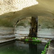

Bakla Tepe Mound located in the south of Menderes (Cumaovası) district, in the immediate vicinity of the Bulgurca Ciftlik Village, which was abandoned due to the Tahtali Dam. The prehistoric settlement extended from the mound to the bottom of the village. During the First World War, an artillery position was placed on the hill. Later,it was covered with soil carried over from the nearby Classical Period settlement by the villagers, causing further destruction. The removal of stones from the mound in house construction caused additional destruction.
At Bakla Tepe different five lsettlement ayers were detected. Bakla Tepe I : Roman - Byzantine . Bakla Tepe II Bakla Tepe II:13th century - EBA III. Early Bronze Age II-Early Bronze Age IIIA. Bakla Tepe IV: Early Bronze Age I. Bakla Tepe V: Late Chalcolithic.
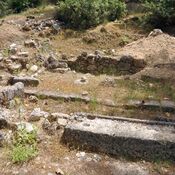
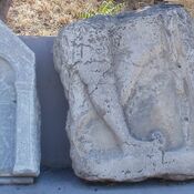
Located in the backward region, an agricultural community of the settlement supplied the maritime trade with food in the fourth and third Millenia BC. The Late Chalcolithic settlement was an open settlement with a diameter of approximately 300 meters and there was no surrounding wall. Pebble-paved streets were between the buildings which were erected on a stone foundation. Abundant metal finds, slag and crucibles in the excavations indicate a developed mining industry. The weaving loom weights (spindle) found during the excavations point a developed weaving industry. Under the floors babies were buried in large jars (pithos) withoutany burial gifts
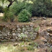
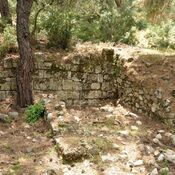
During the Early Bronze Age, the settlement was surrounded by a wall. Although the buildings were based on stone foundations, were connected wtth common roofs together and walls were erected. Then after the abandonment, the settlement was resettled at the end of the Early Bronze Age II. However it was much more smaller and not so regularly planned.
See:
- Excavation at Bakla Tepe: http://www.geocities.ws/irerp_tr/bakla.html
- Bakla Tepe: http://www.tayproject.org/TAYmaster.fm$Retrieve?YerlesmeNo=296&html=masterdetail.html&layout=web