Vici.org
No images available yet. Please add images related to this place.

Surroundings:

Termera, Paton`s TumulusAncient paved RoadThermae of MyndusRoman period schipwreck

Location:

  • Türkiye, Turgutreis
  • geo:37.001392,27.296415
  • Location ± 0-5 m.

Period or year:

  • -6xx~ / unknown

Class:

  • City
  • visible

Identifiers:

  • vici:place=27986

Annotations

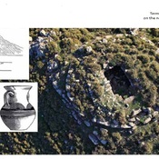
Ancient Legian town Temera (Telmera, Termerea) located on the Asarlık Hill between Turgutreis and Mandra Village, was one of the richest of the eight Lelegian towns before Myndos was founded1. The city was surrounded by thick fortifications, which remains are still visible traced in some places.According to Greek mythology, it was founded by Termerus, after whom it was named.

Sources:

  1. The Geography of Strabo. Literally translated, with notes, in three volumes. London. George Bell & Sons. 1903.
  2. George E. Bean, Turkey Beyond the Maeander. An Archaeological Guide, London Ernest Jersey 1971, p.123-124
  3. Adnan Diler, EARLY IRON AGE TERMERA (ASARLIK), in: KARIA ARKHAIA La Carie, des origines à la période pré-hékatomnide, 2019

References

  1. Next is Termerium,a promontory of the Myndians, opposite to which lies Scandaria, a promontory of Cos, distant 40 stadia from the continent. There is also above the promontory a fortress, Termerum


Nearby

Termera

Lelegian citadel

Termera, Paton`s Tumulus

Lelegian type tomb.

Strobilos - Çıfıt Kalesı in Caria (2 km)

VII century Byzantine fort. Modern Aspat or Çifut Kalesi, fortress and port on the coast of Caria.


This object was added by Aziz on 2016-07-13. Last update by Elżbieta on 2024-01-31. Persistent URI: http://vici.org/vici/27986 . Download as RDF/XML, GeoJSON, KML.
Annotation available using the Creative Commons Attribution-ShareAlike 3.0 Unported license. Metadata available using the Creative Commons Public Domain Dedication, unless it is explicitly stated otherwise.

Vici.org partners:

Livius.org: articles on ancient history   Rijksmuseum van Oudheden