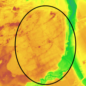
Vici.org
No images available yet. Please add images related to this place.

Surroundings:

Raatakker Landgoed GeijsterenKruikamfoor

Location:

  • Netherlands, Oostrum
  • geo:51.531647,6.003964
  • Location ± 5-25 m.

Class:

  • Rural settlement
  • invisible

Identifiers:

  • vici:place=23932

Annotations

Nederzetting1

References

  1. Gemeente Venray: Archeologische verwachtingenkaart van landbouwers in droge landschappen


Nearby

Nederzetting

Nederzetting

Muntvondst

Muntvondst

Grafveld

Grafveld


This object was added by René Voorburg on 2015-12-21. Last update by René Voorburg on 2015-12-21. Persistent URI: http://vici.org/vici/23932 . Download as RDF/XML, KML.
Annotation available using the Creative Commons Attribution-ShareAlike 3.0 Unported license. Metadata available using the Creative Commons Public Domain Dedication, unless it is explicitly stated otherwise.

Vici.org partners:

Livius.org: articles on ancient history   Rijksmuseum van Oudheden