
There is no English annotation yet. Presented is an annotation in Dutch.

Location:
- Netherlands, Oostrum
- geo:51.534157,6.007526
- Exact location
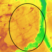
Class:
- Rural settlement
- invisible
Identifiers:
- vici:place=23931
Annotations
Nederzetting1
References
Nearby
Nederzetting
Nederzetting
Muntvondst
Muntvondst
Grafveld
Grafveld