
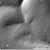
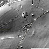
This segment of the extended Portway between Old Sarum and Badbury Rings is called the Ackling Dyke and has an exceptionally high agger. It is road segment 4c in Margary,
 of the Roman Road, Ackling Dyke, looking northeast. The agger is covered in rough grass with the occasional small tree. This uncultivated land is in sharp contrast to the intensive arable agriculture on either side.")
Surroundings:

Location:
- United Kingdom of Great Britain and Northern Ireland, Sixpenny Handley
- geo:50.946136,-1.979024
- Location ± 0-5 m.
Class:
- Road
- visible
Identifiers:
- vici:place=19558
- wikidata:entity=Q4674275
Annotations
Roman Road between Badbury Rings and Old Sarum
Nearby
Roman milestone
Roman milestone
Dorset Cursus
Dorset Cursus Neolithic Cursus. East of Sixpenny Handley
Oakley Down Barrows
Oakley Down Barrows