Vici.org
No images available yet. Please add images related to this place.

Surroundings:

Murs des SarrasinsFontaine Saint-Eloi

Location:

  • France, Saint-Hilaire-sur-Helpe
  • geo:50.139442,3.885102
  • Location ± 0-5 m.

Class:

  • Road
  • visible

Identifiers:

  • vici:place=19048

Annotations

There is no English annotation yet. Presented is an annotation in French.

Voie romaine de Reims à Bavay

Voie romaine de Reims à Bavay


Nearby

Oppidum Avesnelles (5 km)

Oppidum, fortified Celtic town

aquaduct Dourlers (Bavay) (5 km)

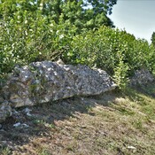
supporting wall aquaduct Bavay at Dourlers

Presumed location of small temple dedicated to Flora (7 km)

presumed temple dedicated to Flora


This object was added by olivier herbinet on 2014-08-14. Last update by olivier herbinet on 2014-08-14. Persistent URI: http://vici.org/vici/19048 . Download as RDF/XML, GeoJSON, KML.
Annotation available using the Creative Commons Attribution-ShareAlike 3.0 Unported license. Metadata available using the Creative Commons Public Domain Dedication, unless it is explicitly stated otherwise.
Line tracing by Ludwinski.

Vici.org partners:

Livius.org: articles on ancient history   Rijksmuseum van Oudheden