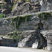
Vici.org

Surroundings:

supporting wall Roman roadsupporting wall Roman road

Location:

  • Italy, Pondel
  • geo:45.676708,7.221845
  • Location ± 0-5 m.

Class:

  • Aqueduct
  • visible

Identifiers:

Annotations

Aqueduct Pondel, Pont d'Aël
 

Tracing

© 2004 - 2011 Cees W. Passchier

See


Nearby

Aqueduct Pondel (2 km)

Aqueduct Pondel

Milestone Saint-Pierre Aosta (CIL 17-02, no. 108) (3 km)

Milestone Saint-Pierre Aosta (CIL 17-02, no. 108), see http://oracle-vm.ku-eichstaett.de:8888/epigr/epieinzel_en?p_belegstelle=CIL+17-02,+00108. Data from http://francia.ahlfeldt.se/

supporting wall Roman road (4 km)

supporting wall Roman road


This object was added by Randal Gilbert on 2013-01-03. Last update by René Voorburg on 2014-09-19. Persistent URI: http://vici.org/vici/12026 . Download as RDF/XML, KML.
Annotation available using the Creative Commons Attribution-ShareAlike 3.0 Unported license. Metadata available using the Creative Commons Public Domain Dedication, unless it is explicitly stated otherwise.
Line tracing by Cees Passchier. All rights reserved - © Cees W. Passchier.

Vici.org partners:

Livius.org: articles on ancient history   Rijksmuseum van Oudheden