Vici.org

Surroundings:

Bourne de Tavernoure

Location:

  • France, Mane
  • geo:43.930153,5.756537
  • Location ± 0-5 m.

Period or year:

  • 1100 / unknown

Class:

  • Bridge
  • visible

Identifiers:

Annotations

There is no English annotation yet. Presented is an annotation in French.

Place to remove, there is no evidence that this is a roman bridge, the last studies date it back max. to the 12th century

http://de.wikipedia.org/wiki/Pont_sur_la_Laye

Place to remove, there is no evidence that this is a roman bridge, the last studies date it back max. to the 12th century


Nearby

Bourne de Tavernoure (2 km)

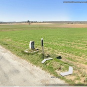
Bourne de Tavernoure, possible Roman boundary marker

Gué du Reculon (5 km)

Permet à la via Domitia de franchir le Reculon

Alaunium (9 km)

Notre-Dame des Anges


This object was added by Randal Gilbert on 2012-12-25. Last update by Seb Saunier on 2019-07-28. Persistent URI: http://vici.org/vici/11613 . Download as RDF/XML, KML.
Annotation available using the Creative Commons Attribution-ShareAlike 3.0 Unported license. Metadata available using the Creative Commons Public Domain Dedication, unless it is explicitly stated otherwise.

Vici.org partners:

Livius.org: articles on ancient history   Rijksmuseum van Oudheden