Vici.org
No images available yet. Please add images related to this place.

Surroundings:

parts of the wallScarbantia Archaeological ParkScarbantia Archaeological ParkMithrasheiligtums bei FertőrákosMithraeum - Fertorakos

Location:

  • Hungary, Sopron
  • geo:47.684898,16.583054
  • Location ± 25-100 m.

Class:

  • Vicus or canabae
  • invisible

Identifiers:

Annotations

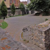
Scrabantia -Scarabantia was a in Pannonia on the Amber Road. As Pliny referred in his Natural History a Celtic hilltop settlement, was used as a place of relocation of veterans in the early Ist cent. AD 1 .

See:

Plin. Historia Naturalis III,146

References

  1. A tergo Carnorum et Iapudum, qua se fert magnus Hister, Raetis iunguntur Norici. oppida eorum Virunum, Celeia, Teurnia, Aguntum, Iuvaum, omnia Claudia, Flavium Solvense. Noricis iunguntur lacus Pelso, deserta Boiorum; iam tamen colonia Divi Claudi Savaria et oppido Scarabantia Iulia habitantur


Nearby

Milestone Sopron-Scarbantia (CIL 03, no. 04654)

Milestone Sopron-Scarbantia (CIL 03, no. 04654), see http://oracle-vm.ku-eichstaett.de:8888/epigr/epieinzel_en?p_belegstelle=CIL+03,+04654. Data from http://francia.ahlfeldt.se/

Scarbantia roman walls

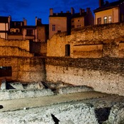
parts of the northern wall visible - right next to the ruins of the forum

Scarbantia Archaeological Park

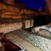
parts of the north-eastern wall and forum visible.


This object was added by René Voorburg on 2012-05-29. Last update by Elżbieta on 2018-03-13. Persistent URI: http://vici.org/vici/1951 . Download as RDF/XML, GeoJSON, KML.
Annotation available using the Creative Commons Attribution-ShareAlike 3.0 Unported license. Metadata available using the Creative Commons Public Domain Dedication, unless it is explicitly stated otherwise.

Vici.org partners:

Livius.org: articles on ancient history   Rijksmuseum van Oudheden